
Google Earth is a treasure trove of unusual and breathtaking sights and symbols. With the emergence of Google’s virtual globe and geographic data program, gone are the days of actually needing to travel halfway across the globe to explore bizarre, exotic locations, natural formations and manmade wonders.
Today, Google Earth has been used to fulfill all manner of objectives, and not just mere exploration. As part of the Google Earth Outreach program, the tool has been put to excellent use, helping a slew of nonprofit organizations. For example, the HALO Trust - a British charity and American nonprofit organization - has used Google Earth to locate and remove landmines, while the World Wildlife Fund has harnessed the tech to improve conservation efforts aimed at protecting Sumatran tiger cubs.
Google Earth recently hit the headlines after being used to explore an enormous piece of artwork, in the middle of an Egyptian desert, which had been sculpted into the landscape. Called the Desert Breath, and spanning a breadth of 100,000 square meters, the environmental artwork was actually created in 1997 and is clearly visible on Google Maps and Google Earth. Its inceptors - Danae Stratou, Alexandra Stratou and Stella Constantinides - believe the art represents a “state of mind.”
Inspired by the group’s artwork, we thought we would have a look at some of Google Earth’s other amazing offerings. The ensuing list shows 10 of the strangest symbols and sights that have been discovered using the technology giant’s remarkable tool.
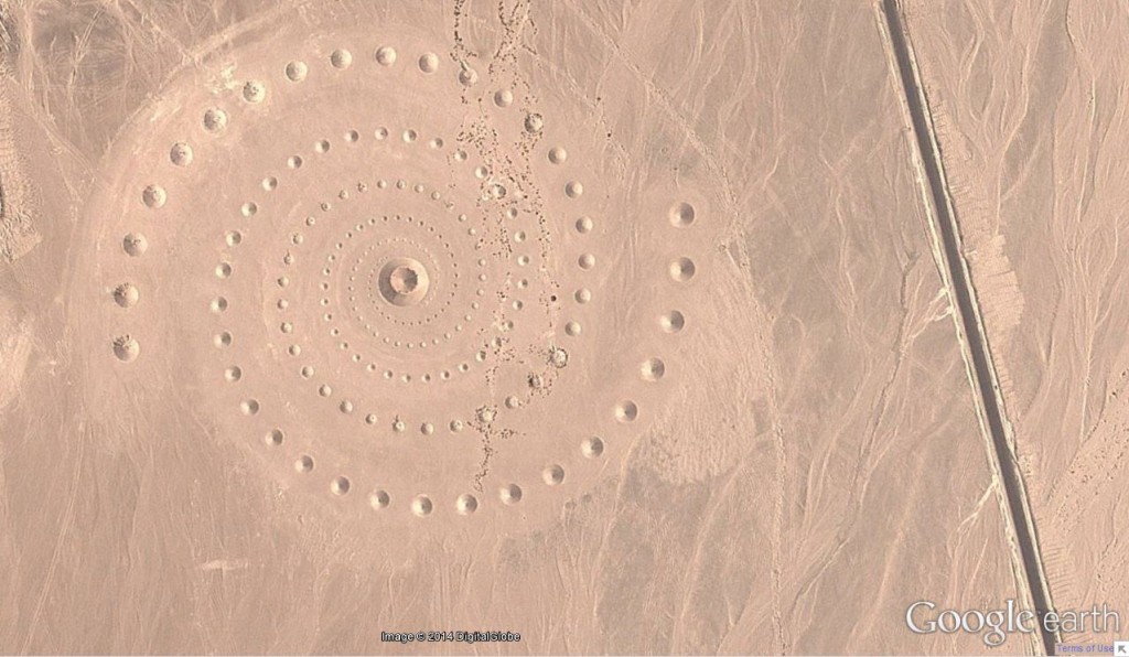
1. The Desert Breath (27°22’50.10″N, 33°37’54.62″E)
Situated in the El Gouna in Egypt, the Desert Breath - as previously mentioned - is comprised of interlocking spiral arms, which are slowly being eroded with the passage of time.
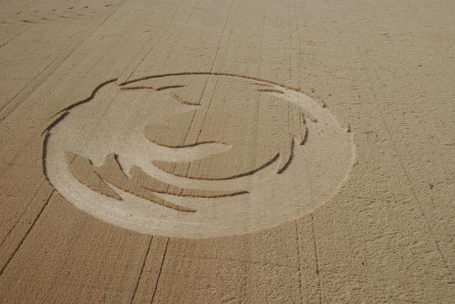
2. Firefox Logo (45° 7’25.87″N 123° 6’48.97″W)
To most tech-orientated minds the inspiration behind this crop circle should be fairly obvious. It is, of course, the Firefox logo. Created in an Oregon cornfield in 2006, the 45,000 square foot crop circle was made by the Oregon State University Linux Users to celebrate the internet browser having surpassed 50 million downloads.
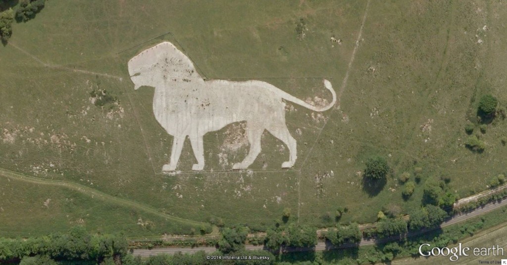
3. The Dunstable Lion… King (51.848637, -0.55462)
Created in Dunstable, in the United Kingdom, this large hill figure was carved into the slopes of Dunstable Downs, inside one of Europe’s biggest wildlife conservation parks - Whipsnade Zoo. Designed by Mr. R. B. Brook-Greaves, the artwork was made as a way marker for park officials. After losing its shape, restoration efforts were conducted in 2005; the occasion was celebrated by surrounding the lion in decorative light strings.
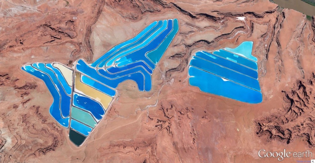
4. Potash Ponds (38°29’0.16″N 109°40’52.80″W)
Based in Moab, Utah, these potash evaporation ponds can be seen at an Intrepid Potash mining facility. Potash refers to salts that boast potassium in water-soluble form, and is mass-produced for use in fertilizers. The mine yields up to 1,000 tons of potash every day, with water from the Colorado River used by Intrepid Potash for routine potash production.
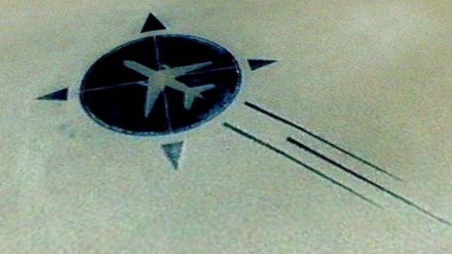
5. UTA Flight 772 Memorial (16.864841, 11.953808)
Looking almost like a perfectly-shaped icon, the Union des Transports Aériens’ (UTA) Flight 772 memorial was built to commemorate the victims that died in a tragic plane crash, in 1989. The incident occurred when UTA Flight 772, which was traveling from the Republic of Congo to Paris, exploded over Niger. The official investigation into the cause of the explosion revealed a bomb had been smuggled aboard the plane by a group of Libyan terrorists.
In quite an astonishing display, the families and friends of the flight’s 170 victims joined forces in searing conditions to build a memorial, using dark stones and pieces of the plane wreckage; as a nice touch, the decorative plane also points in the direction the plane was heading, just before it was taken from skies. Taking the group nearly a month to compile, the 260-foot behemoth memorial remains an absolutely breathtaking spectacle - not just from an artistic perspective, but also when taking into consideration the lengths people will go to for those they love.
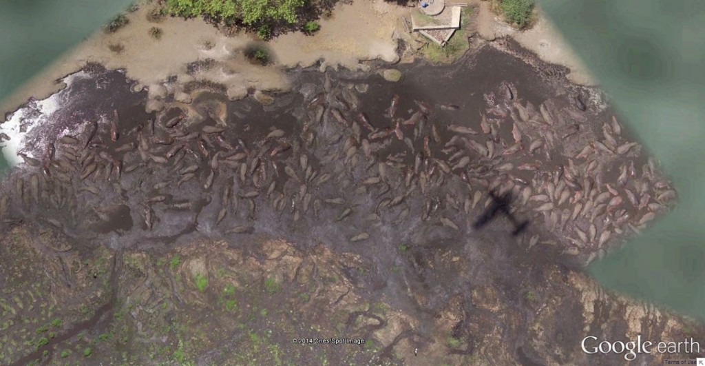
6. Hippo Pool (6°53’53.00″ S 31°11’15.40″ E)
This amazing image was snapped from the Katavi National Park, situated in Tanzania. According to the Tanzania Parks website, Katavi’s most spectacular sight occurs when around 200 hippos converge and flop together in a riverine. However, with many male hippos so densely packed together, highly violent, territorial fights are prone to breaking out.
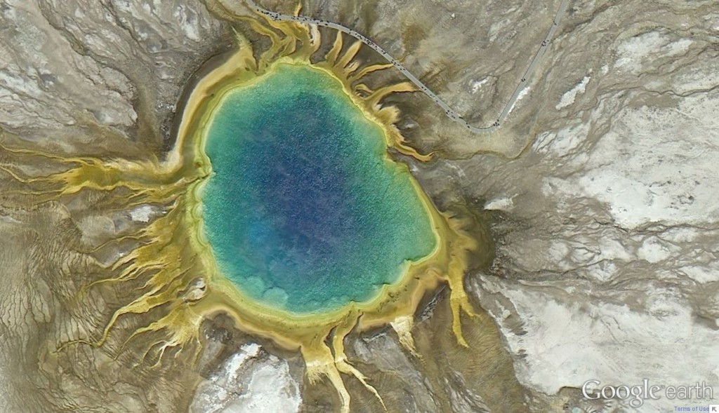
7. Grand Prismatic Spring (44.525049, -110.83819)
Next up in the list is Yellowstone National Park’s Grand Prismatic Spring. Situated in the Midway Geyser Basin, the Grand Prismatic Spring is the park’s largest hot spring - and the third largest in the world - measuring approximately 370 feet in diameter. The intense colors of the spring stem from the various forms of bacteria that grow along the edges of the waters, and are present in differing proportions depending upon the temperature of the water. However, the very center of the pool is completely sterile, due to the extreme temperature.
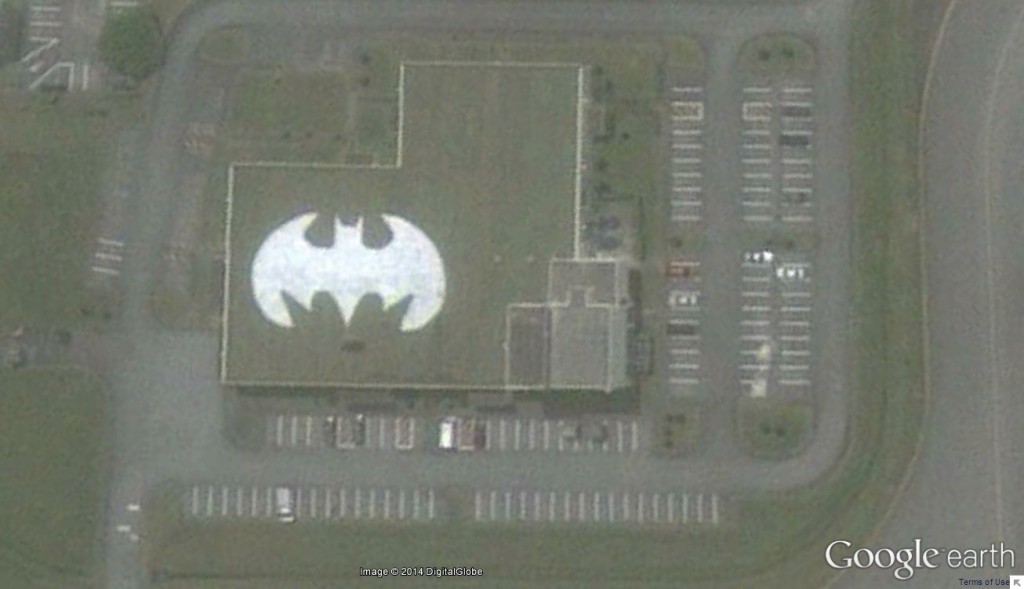
8. The Batman Symbol (26.357896, 127.783809)
On the roof of a U.S. Air Force base in Japan, Google Earth users - much to their astonishment - stumbled across the Batman symbol, around three years back. Stars and Stripes confirmed the image was not a hoax, with the Batman symbol proudly displayed atop the U.S. Air Force’s 44th Fighter Squadron’s Kadena Air Base in Okinawa.
Air base spokesperson Ed Gulick claimed the symbol was painted on the roof during the 1980s, although he was unaware who painted it. Regardless, Fulick believes it gives members of the squadron a sense of pride in their unit.
9. Airplane Boneyard (32 08’59.96″ N, 110 50’09.03″W)
The next image shows an almost endless number of aircraft, sprawled out across Tucson, Arizona. The 309th Aerospace Maintenance And Regeneration Center (AMARC) - a.k.a. The Boneyard - is a U.S. Air Force aircraft and missile storage site, based in the Davis-Monthan Air Force Base.
Currently responsible for over 4,200 aircraft, AMARC actually tries to dispel the myth that the area represents an airplane boneyard. During their stay, the aircraft undergo considerable maintenance to ensure they remain in good condition. Although the group is involved in reclamation of spare parts, along with the disposal of surplus airframes, they also conduct considerable maintenance on many of the stored vehicles.

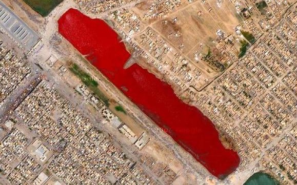
10. Iraq’s ‘Bloody Lake’ (33.39845000,44.48416800)
Iraq’s so-called “bloody lake” has been a source of great speculation, with no official explanation having been given to for its unusual color. Although some of the conjecture surrounding the lake’s appearance has been on the morbid side, others suggest the deep red color to have been caused by pollution, sewage or some form of water-treatment.
Next to each of the image titles, the coordinates have also been included. Please feel free to try entering these coordinates into the search engine of Google Maps to explore the 10 strangest symbols and sights for yourself.


Related Posts:
 Google Exec Breaks World Record By Skydiving 136 Thousand…
 Colors of Yellowstone’s Thermal Springs Revealed
 Google Says Government Demands for User Info Up 120 Percent
 Tungurahua Volcano in Ecuador Spews Ash 10 Kilometers High
 Mozilla and Yahoo Negotiate 5 Year Contract with Future…
 Google Testing Drone Delivery System Called Project Wing